
 |
The Burton Building (1929) Art Deco, Dame Street
|
College Green, in front of Trinity College, merges into
Dame Street, which then becomes Lord Edward Street, after 300 metres – very
busy place with the Temple Bar district on the river side and some much grander
buildings on the other.
A few pictures taken in Temple Bar to be posted soon.

The dome of City Hall can be seen from Parliament Street
in Temple Bar >

The City Hall is on Lord Edward Street. Completed in 1779, it
was originally the Royal Exchange.
Made of Portland stone in neo-classical style.
Made of Portland stone in neo-classical style.

It is well worth having a look inside. It is free and on entering, one is immediately in the Rotunda, the circular hall with the beautiful dome above.

Merchants used to meet in the circular gallery /
ambulatory above the central hall.
It became the City Hall in the early 1850s.
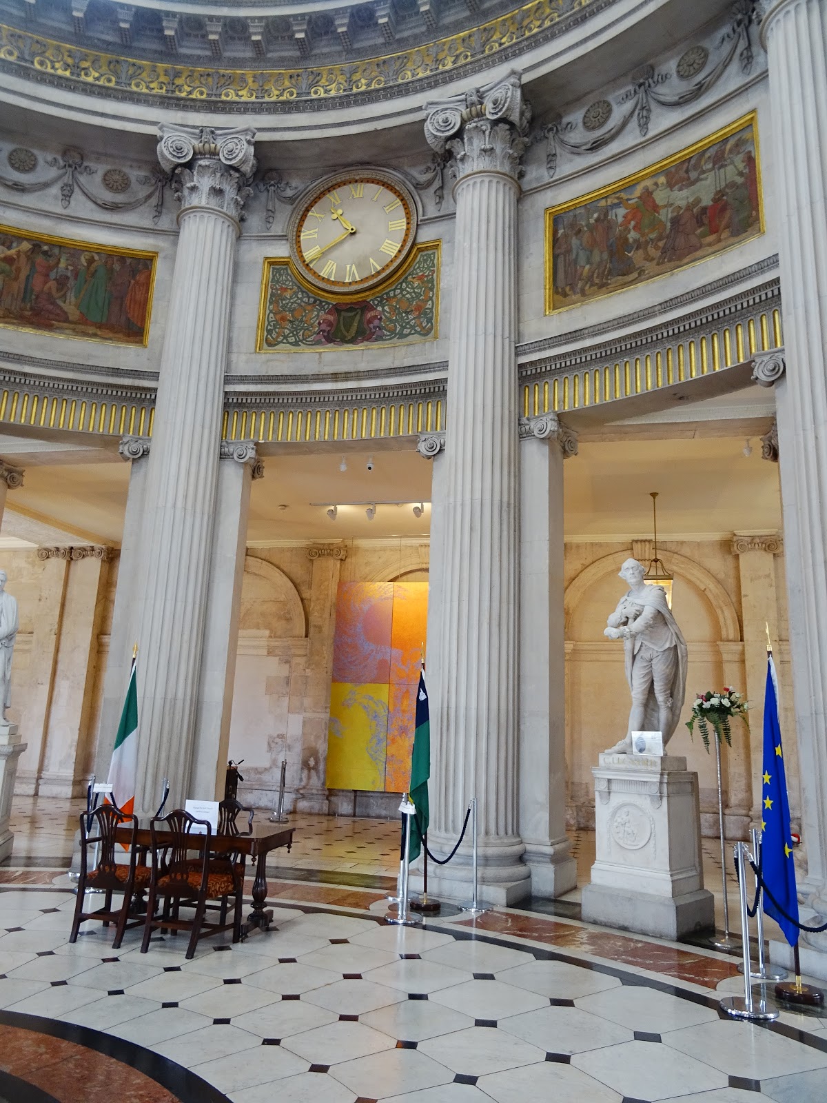
There are twelve columns supporting the dome and
in-between them, some large statues.

This is where wedding ceremonies take place.
The City Council staff, however, work mainly from the modern
Dublin City Council’s Civic Offices at Wood Quay (http://picturesofdubhlinn.blogspot.co.uk/2017/07/fishamble-street-christ-church-cathedral.html).
While the Lord Mayor’s residence is Mansion House, a historic house on Dawson Street.
While the Lord Mayor’s residence is Mansion House, a historic house on Dawson Street.


Some frescoes represent the Provinces of Ireland.
< This is
Connacht, the West of Ireland.

Very large mosaic picturing the city’s coat of arms
(three towers/castles/gateways on fire - nobody knows which nor why) and the
motto "Obedientia Civium Urbis Felicitas" ("the obedience of the
citizens produces a happy city" - a bit of a leading statement…)
The two female figures
are Law (with her sword) and Justice – note that she is not blindfolded… They each hold an olive
branch.

City Hall was restored at the beginning of the 21st
century.
One can wander quite freely it seems… There is some fancy plasterwork
on the next level… Would have needed more time…


Interesting too is to go down in the vaults to see the
exhibition. If only to enjoy the opportunity of seeing below ground.
Photos aren’t good, it was fairly dark and I don’t like to use the flash.
The exhibits are not too numerous and there are some explanatory videos.


^ I do like scale models: on the right, Dublin Castle in the 16th century (http://picturesofdubhlinn.blogspot.co.uk/2017/07/dublin-castle.html).

^ An at-least-444-year-old casket, with 6 locks, that held
the seal of the city (see panel below).


< The ceremonial Great Mace from the civic regalia.


Sword with the Royal coat of arms >

It was King William III’s coat of arms from 1694 to 1702.
With the motto of the Order of the Garter “Honi soit qui mal y pense.”

^ 19th century casket made of bog oak (wood
retrieved from peat bog and usually about 6,000 years old). The feet have been carved into dog figures (Irish
wolfhounds).
This was awarded to John Dillon, an Irish politician who was
imprisoned for supporting the land reform and advising tenants to stop paying
rent as a protest. Silver figurine on top (Freedom).

The Lord Mayor’s chair (1852)
with more Irish Wolfhounds >


This must be one of the rare remaining original posters of
the Proclamation of Independence - read
out on the steps of the General Post Office at the beginning of the Easter Rising
in 1916 >
(I think there is one in Trinity College’s Old Library)
No
close-up photos allowed, so discreet long-lens pic.


There are several pieces of artwork made by Patricia
McKenna, some in bronze, depicting the river flowing with nearby street names,
and Merchant Guilds with related street names – Dublin, where the streets all
have names.


Dublin’s name comes from the Gaelic/Irish “Dubh Linn”
meaning “black pool” and referring to the tidal pool or lake that used to be
present on the site of today’s gardens at Dublin Castle, 300 metres from City
Hall (http://picturesofdubhlinn.blogspot.co.uk/2017/07/dublin-castle.html).
The 10th century Viking settlement of Dyflin was probably
preceded by an ecclesiastical site (Christian ) known as Duibhlinn, but 988 AD
is considered the foundation date of the city.
The capital city also has an official name, in Gaelic,
Bhaile Átha Cliath, which translates as “the town of the hurdled ford.” That
name seems to come from another settlement (Gaelic) which was near today’s
Father Mathew Bridge, 700 metres from City Hall and the site of the first ever
bridge over the River Liffey (http://picturesofdubhlinn.blogspot.co.uk/2017/07/james-joyce-bridge-four-courts.html).

On the City Hall’s
brochure is printed this confusing old map, made by a historian in 1902, but
showing a much older Dublin with fortification walls, gates and towers. An
upside down map, this shows the south of the river and structures that may not
have existed at the same period... City Hall would be near where Dame Gate is
drawn.
But it is not an often
mentioned fact that Dublin was surrounded by walls, because so little remains.
(photos
of a stretch of medieval wall at St Audoen’s Gate and Copper Alley today: http://picturesofdubhlinn.blogspot.co.uk/2017/07/fishamble-street-christ-church-cathedral.html)


Seen from the steps of City Hall: The Oak, a pub since about 1851 (though it wasn’t always
its name), now part of a chain of cafés I think. Dame Street, Temple Bar
district >

^ Behind, City Hall, in red brick is Castle Hall with
Bedford Tower at Dublin Castle (http://picturesofdubhlinn.blogspot.co.uk/2017/07/dublin-castle.html).
On the right, in Portland stone, is the Rates Office, built
in 1781 in neo-classical style, for the banker Sir William Gleadowe Newcomen as his residence and
private bank. 19th c. portico.

This side is a 19th century extension onto
Lord Edward Street >

< It includes a cut stone and marble fountain.

^ Complimentary canvas bag,
very handy for the
complimentary postcards 😃