
 |
Christ Church Cathedral
(in the distance) the spire of
John’s Lane Church
(on the right) St Audoen’s Catholic Church
|

Today’s Christ Church Cathedral is situated in the centre of what used to be the first proper urban settlement in Dublin or the medieval city.
The Vikings fortified camp (9th century AD)
was at today’s Dublin Castle and down to Wood Quay; there was also a Gaelic
settlement and the two cultures merged into a Norse-Irish / Norse-Gaelic / Hiberno-Norse
population.
The 1014 Battle of Clontarf, a sort of revolt against
Brian Boru, High King of Ireland, saw regional kings such as Sigtrygg Silkbeard
Olafsson (King of Dublin) and Máel Mórda mac Murchada (King of Leinster) joined
forces with Vikings (of Danish and Norse descent from the Isle of Man and
Oakney) in vain. The names show the mix of Scandinavian and Gaelic origins. All
a bit confusing… Let’s just say the Irish fought amongst themselves a lot and
still win most of their Olympic medals in boxing…

Anyway, it was Dermot/Diarmait Mac Murchada, dethroned
King of Leinster, who went to England and solicited the support of the English
king; Strongbow (Richard de Clare) was the leading Anglo-Norman knight who
conquered the east of Ireland (Dublin, Leinster). Henry II was the great-grandson
of the Duke of Normandy, William the Conqueror – the Normans being originally
Viking tribes… So that makes Irish History a sort of vodka-cider-beer-poitín cocktail…
quite explosive!

Very little remains of the medieval period: a couple of
towers at Dublin Castle (http://picturesofdubhlinn.blogspot.co.uk/2017/07/dublin-castle.html),
the site of Christ Church, St Audoen’s (church and gate) beside what is marked
as “Original Walls”, The Brazen Head on Bridge Street, itself leading to “The
Bridge 1210” (first bridge over the Liffey http://picturesofdubhlinn.blogspot.co.uk/2017/07/james-joyce-bridge-four-courts.html)
 |
Fishamble Street: Copper Alley Bistro (on right),
Harding Hotel (centre), Darkey Kelly’s Bar is next door (downhill)
|

On the historical map, Fishamble Street and Copper Alley meet, but today the Harding Hotel stands in the way. Having stayed at the Harding Hotel on Fishamble Street, I came across some information about Copper Alley which used to run through what is now the hotel reception. Dating back from the 13th century and following the route of an early Viking street, it became known as Copper Alley in the 17th c. because money was minted here (1608).


Next door is another musical connection: the Handel’s Hotel, named after George Frideric Handel >

This music hall was the venue
where the very first performance of Messiah by Handel took place, in 1742. It
was a charity concert, attended by 700 people. Choirs from the two cathedrals
in Dublin were used. It got a warm reception, unlike in London a year later.
 |
| 1903 |
I read that the archway is all that remains of the entrance to the original site. Nothing else remains. However, once a year, in front of the gates - where is also the Contemporary Music Centre - an open-air performance of Messiah takes place, by Our Lady’s Choral Society.

Hidden behind the gates is a commemorative sculpture…


Between 1885 and 1989, the site had been the Church of SS
Michael and John. It was deconsecrated in 1989 and refurbished as the Viking
Centre. But this was a failure and closed down in 2002. The more recent
Dubliana, near Christ Church Cathedral seems to be more successful (see further
down).
Viking-related artwork at the back of the building: http://picturesofdubhlinn.blogspot.co.uk/2017/07/temple-bar-hapenny-bridge.html

< Right in front of the theatre is this 1988, Viking-inspired sculpture called Baíte (Irish for “drowned”).


< 100 metres, eastward, is this 2002 sculpture called Wood Quay, another Viking longboat’s prow. It stands on Wood Quay, outside the Dublin City Council.

The Dublin Corporation acquired the land to build their offices, on a site that revealed many Viking archaeological finds. Artefacts are on display at the National Museum, and I am guessing that the artwork inserted in the footpath, all around the City Council building and Christ Church Cathedral represent those items.


Indeed, “one of the best preserved Viking sites in the world” was bulldozed in the process, despite senator and future President Mary Robinson marching with thousands of protesters to stop it.
 |
Dublin City Council, Christ Church Cathedral
O’Donovan Rossa Bridge (1816)
|


Founded around 1030 by Irish-Norse King of Dublin
Sigtrygg Silkbeard Olafsson, after he had gone to Rome, it was initially
constructed in wood.
King Henry II of England is known to have visited the
cathedral and received the Holy Communion here, the first time he did so after
the murder of Thomas Beckett in 1171.
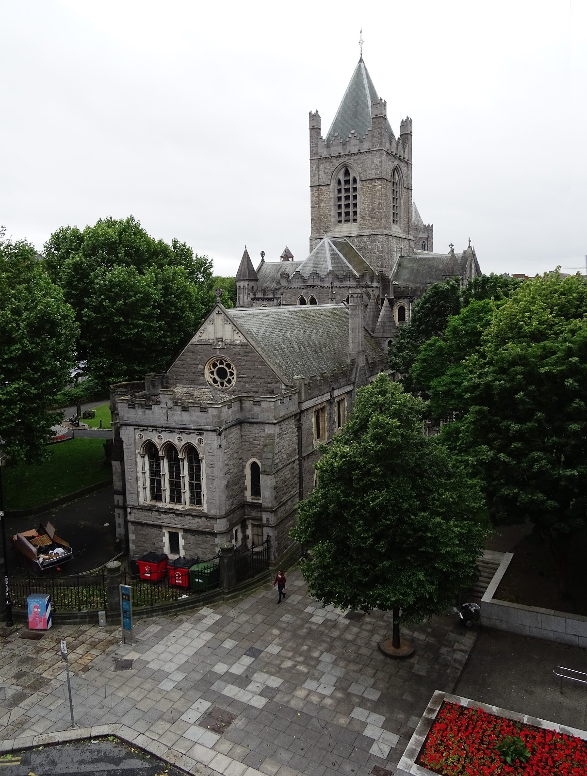
Around 1180, the cathedral was entirely rebuilt in stone,
by the Anglo-Normand knight Strongbow, whose tomb is in the nave.


 |
Gargoyle at the library of the cathedral
|


The cathedral still has its huge medieval crypt (12th c.)
The buttresses are only decorative (19th c.)


 |
Great sheep over the west door of Christ Church Cathedral
|

 |
Winetavern Street
Dubliana / Synod Hall (on left) and
connecting footbridge to Christ Church Cathedral
|


 |
| Christ Church Cathedral |
 |
Christ Church Cathedral (left)
Dubliana / Synod Hall
(with bell tower of St Michael’s Church) (right)
|
^ Paving design must have a significance…


<
Right across Winetavern Street is Cook Street, where one walks past the back of the 19th century St Audoen’s Catholic Church.
The impressive dark wall were built in what is known as black calp, a black or grey rubble limestone commonly quarried in Dublin.
 |
Along Cook Street is a good section of Dublin’s original medieval
City Walls
|

>
St Audoen’s Gate dates from 1240 and, on the slope above it, one can see the tower of another St Audoen’s Church. The oldest parish church in Dublin. Built in the 12th century. Church of Ireland (Anglican). The tower was first built in the 17th century and had to be repaired many times. It houses the oldest bells in Ireland (15th c.)

 |
| St Audoen’s Gate |


James Joyce mentions The Brazen Head in his novel Ulysses.

Next post: The James Joyce’s Bridge - let’s see if “his” bridge is as striking as The Samuel Beckett Bridge…
http://picturesofdubhlinn.blogspot.co.uk/2017/07/james-joyce-bridge-four-courts.html
Here is
Samuel Beckett by Liam O’Neill
(photo taken on Fishamble Street) >